Tag Archives: Sandy

Super-Storm Sandy: Timeline of Destruction

This last week has seen millions of peoples lives devastated by Super-Storm Sandy. Sandy was formed in the Caribbean and it took nine days until Sandy finally began to dissipate over Pennsylvania:

          1.

October 22nd

      A depression forms off the coast of Nicaragua in the South Caribbean Sea.


          2.

October 24th

      Sandy becomes a category 1 hurricane, and passes the Dominican Republic and Haiti. 50 people die in Haiti in mudslides caused by heavy rain.


          3.

October 26th

      Sandy strikes Cuba as a category 2 hurricane (only 1 mph away from being a category 3). Cuba is left devastated.


          4.

October 27th

      As Sandy approaches Florida the hurricane deflects off Florida into the Atlantic, and weakens to a tropical depression.


          5.

October 28th

      As Sandy travels up parallel to the east coast the storm begins to strengthen. Sandy becomes a category 1 hurricane again, and starts to turn towards Baltimore, Washington. Philadelphia, and New York.


          6.

October 29th

      Sandy makes a sharp turn towards New Jersey.  Sandy hits shore around 8pm, near Atlantic City. The full moon adds to the storm surge. The coast of New Jersey, and New York is devastated by the 14 foot surge.


          7.

October 30th

    The storm moves away from New York towards Pennsylvania and begins to weaken.

Super-Storm Sandy left 109 people dead in America, with 40 of the deaths in New York alone. Millions were left without power, gas, or food for days. It is estimated the damage caused by the storm will cost $50 billion.
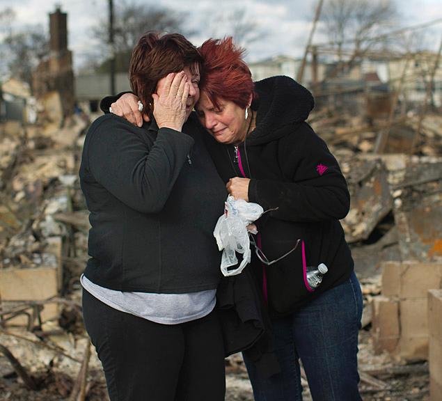
Families return to Breezy Point after devastating fire during Hurricane Sandy destroys 111 houses – NY Daily News


NEw Yorkers comfort each other

 Dozens of families returned to the tight-knit community of Breezy Point on Wednesday, on the western edge of the Rockaway peninsula in Queens, to assess the damage. They were confronted with scenes of utter devastation, with many houses still smoldering.

Homes that did not burn had major flood damage, and houses on waterfront sites suffered wind damage, with some homes blown off their foundations and smashed together.

Of the 2,800 homes in Breezy Point, 111 homes were completely destroyed, an FNDY official said Wednesday. And 20 homes had some level of fire damage.

Though there were only a few minor injuries reported among residents and firefighters, officials have not ruled out the possibility that there may have been fatalities in Breezy Point, said Joe Downey, FDNY Chief of Special Operations, who was conducting search and recovery on Wednesday.

Fire officials said the cause of the inferno, where more than 200 firefighters responded, remains unclear.

via Families return to Breezy Point after devastating fire during Hurricane Sandy destroys 111 houses – NY Daily News.

DOE – Science – ASCR Discovery

Refining hurricane forecasts by connecting the dots

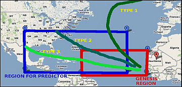
Hurricane origin - Africa

Predictions of North Atlantic hurricane paths based on spatio-temporal data at the region of origin, off the coast of North Africa. Click image to enlarge and for more information.

By graphing points in Earth’s roiling atmosphere with the aid of the latest petascale-power technology, scientists collaborating on Department of Energy-funded research say they could improve major seasonal North Atlantic hurricane forecast reliability by more than 25 percent.

“We ask questions about the end-game of hurricanes: Where will they likely end up in 10 or 15 days?” says Nagiza Samatova, an associate professor in computer science and mathematics at North Carolina State University and a senior research scientist at Oak Ridge National Laboratory.

“We are finding local impacts using global data,” adds Alok Choudhary, Samatova’s collaborator and John G. Searle professor of computer science and electrical engineering at Northwestern University.

After a few years of sleuthing through existing climate records, their work is revealing previously unknown but predictive links between distant places that seem to recur during peak years for hurricane activity.

for more, view: DOE – Science – ASCR Discovery


.

Tropical Storm Sandy: Death tolls begin to rise

As Sandy makes her way across the north east there have already been at least 13 deaths caused by the super-storm.  This is expected to rise.

Sandy made landfall near Atlantic City, New Jersey. The storm surge in Manhattan caused by the storm has left lower Manhattan under water. Mayor Michael Bloomberg said the surge was higher than even the highest predictions. Much of Manhattan is now without power, subways are flooded and water pours into Battery Tunnel – linking Lower Manhattan to Long Island. There are reports of an explosion in the Con Edison power station on the east side of Manhattan.

In New Jersey, the Oyster Creek nuclear plant has been placed on alert due to the rising water.

Expects warn the super-storm could remain over the country for the next 24-36 hours. Although the super-storm was downgraded from hurricane status after landfall, Meteorologists warn not to downplay the seriousness of the storm, which is still giving hurricane strength winds: this could be the worst storm in US history.

Disaster estimating firm Eqecat has forecast that Sandy could cost the economy between $10bn- $20bn. The New York Stock Exchange will remain closed again today.

New Jersey Starting To Feel Sandy’s Impact

The East Coast is starting to feel the impact of Sandy, ahead of land fall. It is thought the hurricane will make landfall in New Jersey. Ahead of the storm coastal towns are already seeing flooding, and in New York the high winds have caused the partial collapse of a crane.

The storm is continuing to intensify as it approaches land. Meteorologists are expecting a coastal surge of 20 feet. After landfall the main the storm is expected to slow down it’s forward pace. This means Sandy will take several days to clear.

For more information see Fox News

What is causing Sandy to be a Super-Storm


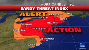
Hurricane Sandy Impact Map

Although Sandy is currently a hurricane, this is not like a normal hurricane. Sandy is a hybrid-storm, or extratropical storm. There are a number of factors for this. Firstly, the Jet Stream that normally sits high above Canada has slipped down over the US, bringing with it an arctic blast – this is why the north west saw snow this week.

An early winter’s storm from the north is feeding into the warm air of the hurricane and intensifying the storm. It is expected there will be heavy snow showers on higher ground.

To the north east, Sandy is encountering a ridge of high pressure from Greenland. These three weather types together have merged into a super-storm, with a reach of over 800 miles.

Sandy started as a hurricane in the Caribbean, and moved up the east coast where she has whipped up the ocean, to create a massive coastal surge. Also, the Full Moon causes higher than average tides, therefore the massive coastal surge is expected to result in extensive flooding. Delaware coastal residents have been told to evacuate, and some predict the New York subway could be flooded.

The combination of high winds, heavy rain and snow is expected to result in widespread power outages, and New York residents have been told to prepare for a couple of days without power. The storm is expected to impact a third of the country.

Panic Grips New York Ahead of Frankenstorm

Hurricane Sandy, also known as Frankenstorm is due to hit the north east tomorrow, and fear is gripping New York residents. Frankenstorm is already being felt in North Carolina where the rain and high winds have begun. Meteorologists are saying Sandy is a “perfect storm”, and could impact 60 million people along the north east coast.

Sandy is no ordinary hurricane, but a hybrid storm, with a reach of over 800 miles – people from the coast to the Great Lakes have been told to prepare. Residents along Delaware’s coast have been evacuated. Some estimate that the super-storm could result in 15-foot seas, resulting in extensive coastal flooding.

A similar storm hit the eastern seaboard in 1991, and was made famous by Sebastian Junger’s best-selling book, “The Perfect Storm”. In 1991 the damage was terrible, but this time round meteorologists predict the depression is much deeper and the storm more severe.